At ICAR-Indian Institute of Horticultural Research (ICAR-IIHR), Bengaluru, Geographic Information System (GIS) technology is being employed to drive research and innovation. The following are key highlights of how GIS is being utilized for horticultural advancements and addressing critical challenges in horticulture and environmental management:
Soil Erosion Assessment in Arunachal Pradesh
Researchers utilized the Revised Universal Soil Loss Equation (RUSLE) combined with GIS tools to evaluate soil erosion in the Diyun block, Changlang district, particularly near rivers and streams. The integration of remote sensing and GIS technologies provided valuable insights into erosion-prone areas and facilitated the development of effective soil conservation strategies. For more details, visit DOI: 10.59797/ijsc.v51.i3.133.
Delineation of Crop Management Zones
In the north-eastern Himalayan region, GIS tools were used to define nutrient management zones (MZs) based on soil properties and terrain attributes. By analyzing 896 grid-based soil samples with regression kriging and fuzzy clustering, the area was segmented into four distinct MZs. This approach supports site-specific nutrient management and enhances sustainable agricultural practices. For further information, see DOI: 10.3390/rs14092101.
Water Conservation at ICAR-IIHR Farm
At ICAR-IIHR’s Hesaraghatta farm, a study employed GIS and hydro-geological analyses to optimize water use. Researchers assessed infiltration, runoff, and percolation to identify potential sites for rainwater harvesting and groundwater recharge. This research aims to improve water management amidst declining resources. For more details, refer to DOI: 10.24154/jhs.v12i2.20.
Micronutrient Imbalances in Fruit Crops
GIS techniques were applied to assess the spatial variability of soil and plant nutrient levels in mango orchards. The study highlighted significant variations in micronutrient levels, such as zinc, emphasizing the need for precision agriculture to address nutrient deficiencies and improve crop health.
GIS-Based Mapping for Onion and Cashew Cultivation
GIS tools were utilized to create detailed maps of onion (aggregatum group) growing districts of southern India and cashew cultivation areas across India. These maps provide crucial information for optimizing crop management practices and enhancing productivity by identifying key cultivation zones and managing resources effectively.
Mapping of Indian Genotypes of Centella asiatica
Geospatial mapping of Centella asiatica germplasm collection sites was carried out to study morphotypes and seasonal yield variations. This research contributes to the development of effective cultivation strategies and provides insights into the plant’s distribution and potential across India. For detailed insights, refer to DOI: 10.1016/j.sajb.2021.11.024.
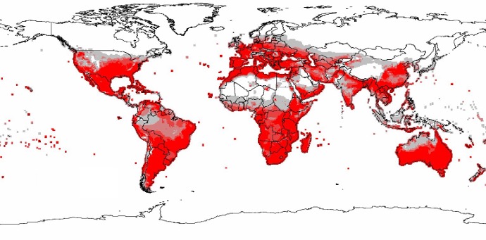
Climate Impact on Tomato Pests and Natural Enemies
Using CLIMEX software and GIS, researchers modelled the global potential distribution of tomato pests (Phthorimaea absoluta) and their natural enemies under current and future climate scenarios. The study assessed the impact of temperature increases (1°C and 2°C) and Representative Concentration Pathways (RCP 8.5) on pest distribution. Locations were categorized based on Ecoclimatic Index values, offering critical information for developing pest management strategies in response to climate change.